What: Bull Creek Water Quality Protection Lands Trail Opening
When: November 9 2007 at 10 am (comments), 10:30 am: Tour
When: November 10, 2008: tour at 10 am, tour at 12 noon.
Who: General Public, city and county officials, press
Contact: Charlie McCabe, cmccabe@austinparks.org, 512.965.1960
Why: The first of two trails to open on City of Austin Water Quality Protection Lands, this is a 1.5 mile trail built and maintained entirely by volunteers. Come hear a quick review of its construction and take a tour of the site.
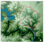
On Friday, November 9th at 10 am, the Bull Creek Foundation and the City of Austin Wildlands Conservation Division will celebrate the official opening of the Matthew Smith trail on the Bull Creek Water Quality Protection Lands tract. This 1.5-mile hike and bike interpretive trail is the first to open on City of Austin Water Quality Protection Lands (WQPL). The 60-acre Bull Creek tract, also known as the Stenis tract, was purchased with Bond funds after a successful 1998 election. Volunteers from the Bull Creek Foundation participated in a public process to define possible public uses for City WQPL in 1999-2000 as part of an overall land management plan which was approved by City Council in late 2000.
A memorandum of agreement between the Foundation and the City was signed in 2003, followed by a formal application permit process which was finalized in late 2005, allowed trail construction to begin in January 2006. Thanks to countless hours contributed by volunteers, Eagle Scout and school projects, the interpretive trail is about to open and will be maintained by volunteers from the Bull Creek Foundation.
So come hear the stories, the thanks and tour the trail. For those who cannot make it on Friday, November 9, we'll host tours of the trail on Saturday, November 10th at 10 am and 12 noon.
Directions to the trail head and parking. Parking is very limited. Carpool if you can or be prepared to walk a short distance.
Traveling North on Loop 360 ( from FM 2222 and other points south) - Head north on Loop 360, you'll pass through the traffic signal at Lakewood Drive. Move into the left lane and take a left at the next traffic signal at Spicewood Springs road. (Only a left turn is possible) Once on Spicewood Springs Rd, turn right onto the low water crossing road and take an immediate right into the parking lot area.
Traveling: South on Loop 360 (from 183 and other points north) - Head south on Loop 360, you'll pass through several traffic signals at Great Hills and Spicewood Springs / Bluffstone Drive. Move into the right lane and take a right at the next traffic signal at Spicewood Springs road. (Only a right turn is possible) Once on Spicewood Springs Rd, turn right onto the low water crossing road and take an immediate right into the parking lot area.
About the Bull Creek Foundation - We're an all volunteer affiliate of the Austin Parks Foundation, working on park and trail projects in the Bull Creek watershed. More info at: bullcreekfoundation.blogspot.com or www.bullcreek.net
Subscribe to:
Post Comments (Atom)


No comments:
Post a Comment